Posts

Showing posts with the label London

London's rail system (in 60 seconds!)

Image
Simon Rogers shows how it is done - by using CartoDB to pull together an animated 60 second take on all of London's rail and tube systems based on when they opened. ( Heres the detail on how he did it ...) Can’t see this visualisation? Click here

London Rental Prices near Underground Stops - a #Visualization

Image
via Find Properly , we have this (somewhat) nifty interactive take . Its pretty nifty (especially the morphing between the Beck and Geographic maps), but it would have been even nicer to have a summary of some kind show up as a hover/tool-tip. Its embedded below, but go to the original to get the full experience ...

What if the London Tube Map was Geographically Accurate?

Image
mapFodder has warped London to make it conform to the tube map, and the results are remarkably cool.  Its not just the skewed perspectives in the periphery, check out how remarkably straight (and non-twisty! ) the Thames is... And, of course, check out the video below to see the warping in action...

Every bomb in the London Blitz - Visualized

Image
From Bombsight , comes this visualization of the London Blitz showing the location of every bomb dropped.  The images below are just that - images.  For the real thing go here (I've centered around Buckingham palace - it is one of the more recognizable areas :-)) And, FWIW, once you zoom out, the density of the bombing is quite frightening - its when you look at this that you realize the true gulf between the American and British experiences of WWII ...

Where stuff is Banned in London - Visualization

Image
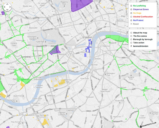
From BannedInLondon , we have this (not so) little piece of awesomeness - a visualization of every area where stuff is banned.  To quote You are in danger of unwittingly committing an offence if you stray into one of 435 special zones in London. The boundaries of these zones are often unmarked and within them many everyday activities are either banned or restricted. A new Manifesto Club online Google map,   Banned in London , reveals the 435 special zones that now cover half the area of the UK capital. In these areas, people can be fined or prosecuted for activities that would not otherwise be an offence - including leafleting, protesting, dog walking, gathering in groups, and drinking in public. Go to the actual interactive map , the below is just an image...