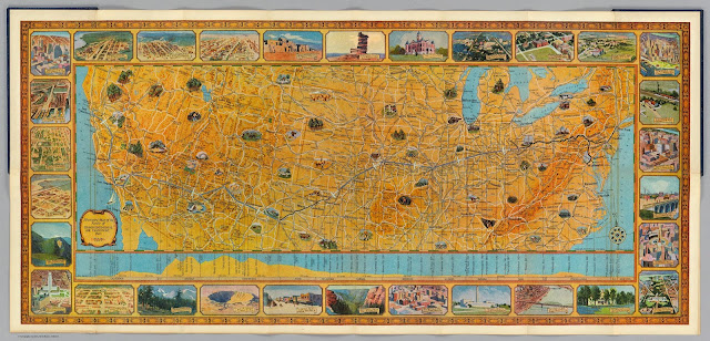
From Slate - a scan of an old souvenir fold-out map, given to passengers going cross-country via Transcontinental Air Transport (TAT) in 1929. From the site Despite the company’s name, the trip was not quite transcontinental—as you can see on this map, passengers took a train to Columbus, Ohio, then another from Waynoka, Okla . to Clovis, N.M. In between, they flew in Ford Tri-Motor planes with a capacity of 10 to 12 passengers and wicker seats. Passengers flew by day so they could see the sights and slept on the trains at night . The map’s borders feature scenes of the American landscape, showing places that the passengers could expect to see from the ground (Clovis’ main street) and from the air (the campus of the University of Missouri, Los Angeles’ new City Hall). The trip took 48 hours altogether in ideal conditions. David Rumsey notes that on the back of this map, Mason Menefee, the passenger who owned it, f...